The Smokies Offer The Best Section of The Appalachian Trail
Of the 2,147 miles that comprise the AT, the Great Smoky Mountains National Park accounts for 71 miles. Of the National Park’s 848 miles of trails, the AT is by far the most popular. Kuwohi (formerly Clingmans Dome) is the highest point on the AT at 6,643′, and Fontana Dam is the only dam crossing on the AT.
The Trail through the Smokies also has the most rainfall and snowfall on the AT. in the South, and many hikers are caught off-guard by the snow and cold temperatures at high elevations. The temperatures at 5000 feet can be 10 to 20 degrees cooler than the valleys around Bryson City.
New: Parking tags are required to park in the Great Smoky Mountains National Park. Tags can be purchased online or on-site. $5/day, $15/week or $40/year. Parking Info
You Read The Book, You Saw The Movie.
We Have The Real Thing.
In the film A Walk in the Woods, Robert Redford & Nick Nolte star as old friends who — ready or not — decide to hike the AT. Based on Bill Bryson’s bestseller, the movie co-stars Emma Thompson, Mary Steenburgen, Nick Offerman & Kristen Schaal.
The movie has put a spotlight on the Smokies’ most popular trail — ‘our’ spectacular 71-mile section of the 2,190-mile AT.
While most of the film was shot in Georgia, one scene has the intrepid duo walking across Fontana Dam on their way to the Great Smoky Mountains National Park.

Seven ‘Walks in the Woods’
There are several segments of the AT in the Bryson City, Swain County area offering the opportunity for walks in the woods. Some of the day hikes are ‘out-and-back’. Others are one-way hikes requiring two vehicles or a shuttle. One is a three to four day, 40-mile backpacking trek.
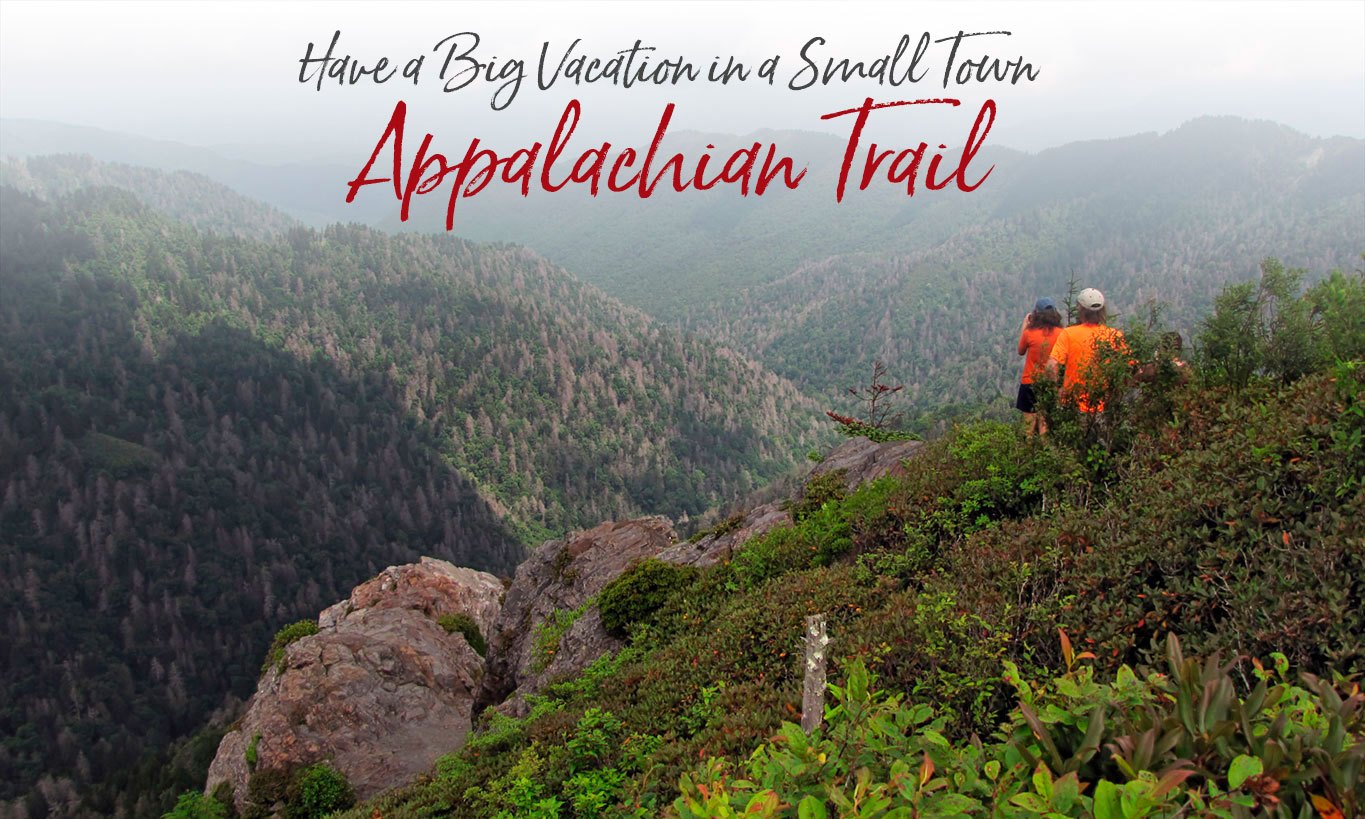
The most popular and accessible AT hike is the 4 mile segment from Newfound Gap to Charlies Bunion, a rocky cliff with one of the best views in the Smokies.
AT HIKES
Newfound Gap to Charlies Bunion
8 miles miles round trip, out and back
Difficulty: moderate
Elevation range:
Newfound Gap 5049’
Highest point 6222’
Charlies Bunion 5565’
Directions to Newfound Gap — From the Oconaluftee Visitor Center in Cherokee, take US 441 (Newfound Gap Road) 16 miles north to the Newfound Gap overlook and parking. Take the trail east. See video below.
Newfound Gap to Kuwohi (formerly Clingmans Dome)
7.5 miles one way
Difficulty: moderate
Elevation range:
Newfound Gap 5049’
Low point at Collins Gap 5005’
Kuwohi 6625″
Kuwohi is the highest point on the entire Appalachian Trail and the third highest peak east of the Mississippi. The observation tower on the summit of Kuwohi offers spectacular 360° views of the Smokies and beyond for visitors willing to climb the steep half-mile walk to the tower at the top. The trail parallels Kuwohi Road, but on the other side of the ridge well away from the traffic noise. With parking lots at both ends of this hike, you’ll need two vehicles. And keep in mind that the road to Kuwohi is closed each winter, December 1 thru March 31. Directions to Kuwohi — Turn off Newfound Gap Road 0.1 mile south of Newfound Gap and follow the 7-mile-long Kuwohi Road to the large parking area at the end. Take the trail west. Directions to Newfound Gap — From the Oconaluftee Visitor Center in Cherokee, take US 441 (Newfound Gap Road) 16 mile north to the Newfound Gap overlook and parking. Take the trail east
Fontana Dam to Shuckstack Tower
7 miles round trip, out and back
Difficulty: strenuous
Elevation range:
Fontana Dam: 1837’
Shuckstack 4020’
Directions to Fontana Dam — take US-74 and NC-28 west of Bryson City for 32.5 miles. There’s a parking lot and welcome center at the dam. Cross Fontana Dam (the only dam crossing on the AT) and continue 0.6 mile to the trailhead. Hike the steep trail north towards Birch Spring Gap and Doe Knob. The trail climbs more than 2100 feet, with most of that elevation gain coming in the first 2.4 miles.
Yellow Creek Gap to Fontana Dam
7.8 miles one way
6-7 hours
Difficulty: strenuous
Elevation range:
Yellow Creek Gap 2,980’
Highest point 3,786
Fontana Dam 1,837’
Directions to Yellow Creek Gap: The Yellow Creek Gap trailhead is about 26.4 miles from Bryson City. Travel west on US73 to NC28 North. Continue on NC28 passing thru the tiny Stecoah community to Upper Tuskeegee Road. Turn left and watch for the AT trail crossing sign. This is an easy ‘drop off’ point, with a small parking area.
Stecoah Gap to Yellow Creek Gap
7.6 miles one way
6-7 hours
Difficulty: moderate, with several short steep climbs
Elevation range:
Stecoah Gap 3,165’
Highest point 3,912’
Yellow Creek Gap 2,980’
Directions to Stecoah Gap — From Bryson City, travel west on US73 to NC28 North. Continue on 28 passing thru the tiny Stecoah community to the intersection with NC 143 (almost 21 miles from Bryson City). Turn left and continue to the top of Stecoah Gap. There’s parking for about seven cars.
Wesser to Stecoah Gap
13.6 miles one way
10-11 hours
Difficulty: strenuous
Elevation range:
Wesser 1723’
Highest point 5,062’
Stecoah Gap 3,165’
Very steep eight-mile uphill climb from the Nantahala River (1723’) to Cheoah Bald (5,062’) and then long descent to Stecoah Gap
Directions: The AT crosses US19 at the Nantahala Outdoor Center in Wesser, 14 miles west of Bryson City. Parking is available.
BACKPACKING HIKE
Fontana Dam to Newfound Gap
3-4 days
40.5 miles one way
Difficulty: moderate, portions strenuous
Elevation range:
Fontana Dam 1837’
Clingmans Dome 6625’
Newfound Gap 5049’
Fontana Dam is 32.5 miles west of Bryson City, via US74 and NC28. There’s a parking lot and welcome center at the dam. Cross Fontana Dam and continue 0.6 mile to the trailhead. Hike the steep trail north towards Birch Spring Gap and Doe Knob. The trail climbs more than 2100 feet, with most of that elevation gain coming in the first 2.4 miles.
Important: All hikers camping in the backcountry are required to purchase a permit in advance. You will also need reservations at the shelters unless you are thru-hiking (defined by the park as starting your hike more than 50 miles outside the park and ending your hike 50 miles beyond). More information about the special regulations in the Great Smoky Mountains National Park can be found on the National Park Service’s permits page.
Shuttle Services
Carolina Bound Adventures (Bryson City)
Bryson City Outdoors (Bryson City)
A Walk in the Woods (Bryson City)
Guided Hikes
Carolina Bound Adventures (Bryson CIty)
A Walk in the Woods (Bryson City)
AT News & Information
AppalachianTrail.com is an informational resource for planning an AT hike and learning about the history of the trail — from various wildlife you might encounter on the Trail to the best movies featuring the AT.
Leave No Trace
![]()
An estimated 3 million people hike some portion of the Trail each year. To protect the trail, The AT Conservancy, which works to preserve and protect the natural beauty and cultural heritage of the trail, AT, urges all hikers to follow these seven principles:
• Plan ahead and prepare
• Travel and camp on durable surfaces
• Dispose of waste properly
• Leave what you find
• Minimize campfire impacts
• Respect wildlife
• Be considerate of other visitors
• The Appalachian Trail is managed by the National Park Service.
A Hike to Charlies Bunion
Photo credits (top)
View of Fontana Lake from Shuckstack fire tower – Photo by coloneljohnbritt – Creative Commons
Two people at Charlies Bunion – Photo by Frank Kehren – Creative Commons
Bryson City - Swain County
Chamber of Commerce
P.O. Box 509
1191 Main Street
Bryson City, NC 28713
Hours 10am – 2pm
Mon, Tues, Thurs, Fri
Ricky Sanford
Administrative Coordinator
828-488-3681

Order a free Visitor Guide featuring Bryson City and the North Carolina Smokies
*