
Each year, thousands get away to Bryson City for a memorable Smoky mountains escape. But few getaways are as memorable as Richard Kimball’s 1993 escape from Deputy Marshal Samuel Gerard. That’s when “The Fugitive” Kimball (Harrison Ford) leapt from the top of a tall hydroelectric dam dam into the icy water below.
With Western North Carolina substituting for northern Illinois, many of The Fugitive’s early scenes were filmed in and around Bryson City, including the spectacular train wreck in Dillsboro and scenes of Harrison Ford driving a borrowed getaway vehicle through downtown Bryson City. The iconic dam sequence was filmed at the historic Cheoah dam on the Little Tennessee River about 40 miles west of Bryson City. It’s a must-see attraction for visitors.
OK, forty miles may be a lot of driving just to see one dam. But with so much more to see and do along the way, we think you’ll love “The Fugitive” Escape Day Trip.

Richard Kimball’s dramatic escape

Approximately 100 Miles, An All-day Trip
Much of this drive goes through rural Western North Carolina. So be sure to gas-up before leaving Bryson City.
1. Bryson City to Stecoah – 19 miles via US 19/74 & NC 28N (23 minutes)
You’ll cross two bridges over Fontana Lake, the 29-mile-long, 10,230-acre TVA reservoir for Fontana Dam, a popular fishing, boating and swimming destination. An overlook offers a spectacular panorama of the Great Smoky Mountains National Park skyline, including Kuwohi (formerly Clingmans Dome).
In the tiny village of Stecoah, visit the Stecoah Valley Center Artisans Gallery, a unique opportunity to buy original artwork and the fine crafts created by area artisans.
Optional side trip — 1.5 miles west of Stecoah, turn left on to NC 143 and drive 1.8 miles to 10. Stecoah Gap, a 3165-foot mountain peak where the Appalachian Trail crosses the highway. There are picnic tables where you might meet AT hikers taking a break. Enjoy the view.

Stecoah Artisans Gallery
2. Stecoah to Fontana Dam – 12.8 miles via NC 28N (20 minutes)
Most of the drive to Fontana is through the densely-wooded Nantahala National Forest. As you reach the Fontana area, you’ll see signs for Fontana Village Resort & Marina and Fontana Dam. The privately-owned vacation resort was originally built as a town for the workers who constructed the dam between 1942 and 1945. Seasonal dining options are available, but call first: 800-849-2258.
Follow the signs downhill to the Fontana Dam visitors center which is open 9 am to 7 pm daily, mid-April to November. Inside, there are exhibits describing the dam and its history. Outside, there are views of the dam, the spillway and the Great Smoky Mountains National Park beyond. You can walk across the dam — it’s part of the Appalachian Trail — or drive to a small park on the other side. The 480-foot-high dam is the highest in the Eastern United States and the fourth highest in the nation.
There’s another view from below the dam that you can see after leaving Fontana Village. On NC 28, about three miles past Fontana, the highway crosses the Little Tennessee River. Immediately past the bridge, turn right and follow the short road to the base of Fontana Dam.

Fontana is the tallest dam east of the Mississippi

Walk across the dam and you’ve hiked part of the AT
3. Fontana Dam to “The Dragon” – 9.3 miles via NC 28 (15 minutes)
The drive west follows the shoreline of Cheoah Lake and ends at a “T” intersection with US 129 at Deal’s Gap, NC. Deal’s Gap is world-famous among motorcyclists and sports car drivers for “The Dragon” an eleven-mile section of US 129N into Tennessee with 318 continuous curves.
Even though driving “The Dragon” may be an adventure for another day, be sure to stop at two motorcycle-oriented roadside attractions. At Deals Gap Motorcycle Resort, don’t miss the “tree of shame”, a makeshift shrine to riders who left a little of their gear behind somewhere along the way. Across the street, “The Tail of the Dragon” motorcycle and souvenir shop features a giant metal dragon sculpture.

The Dragon’s ‘tree of shame’
4. Geal’s Gap to Cheoah Dam – 1.8 miles via US 129S (5 minutes)
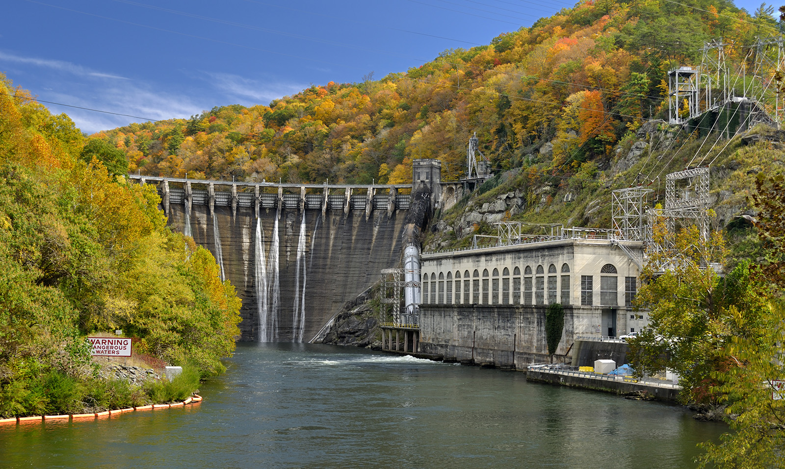
As you cross the Little Tennessee River, you’ll see where Richard Kimball made his daring escape. Built in 1919, Cheoah is the oldest dam on the Little Tennessee. At one time, it was the world’s tallest overflow dam at 225 feet and had the largest turbines in the world.
5. Cheoah Dam to Tapoco Lodge – .7 miles via US 129S (2 minutes)
The Historic Tapoco Lodge was built in 1930 by the Aluminum Company of America as part of hydroelectric efforts in Graham and Swain counties, including the Cheoah and Fontana dams. Today, the Lodge’s popular Tavern has riverside patio dining on the banks of the Cheoah River. Open mid-March thru December. (828) 498-2800

Riverside dining at the Tavern at Tapoco Lodge
6. Tapoco Lodge to Yellow Creek Falls Trailhead – 3.9 miles via US 129S (5 minutes)
If you’re up for a short hike, try the 1/3 mile (each way) trail to Yellow Creek Falls. Look for a small parking area. This trail leads to a 50-foot waterfall and swimming hole with nice cascades along the way. Rated moderate given the incline/decline due to rocks, roots and mud. Hiking shoes recommended, and possibly a hiking pole after rain. Leashed dogs okay.
7. Yellow Creek Falls Trailhead to Robbinsville – 11.3 miles via US 129S (15 mins)
The drive to Robbinsville follows the Cheoah River, known for one of the most challenging whitewater rafting courses in the southeast. Normally an easy-flowing river, each year there are at least a dozen scheduled dam releases creating class IV and V rapids that experienced paddlers can enjoy for the day.

A popular attraction in Robbinsville is Wehrloom Honey & Meadery at 257 Willie Colvin Road. 828-735-2300
On the way to Robbinsville, you may want to consider these optional side trips:
A. Joyce Kilmer Memorial Forest – On US 129, about three miles south of Yellow Creek Falls, look for a small sign pointing to Joyce Kilmer Memorial Forest, one of the few remaining old-growth forests in the Appalachians. Take the 6.5 mile drive to the Ranger station where a 2 mile figure-eight loop hiking trail leads to some of the forest’s largest poplars, some estimated to be over 400 years old. Leaving, you can back-track to US 129, or follow NC 143 south toward Robbinsville (13 miles).
B. Lake Santeetlah – While there are many places to view the lake, this may be the easiest: Just past the Joyce Kilmer sign, look for Thunderbird Mountain Road on the right. Take the sharp left turn and continue a short distance to Cheoah Point Beach, boating access, campground and a ranger station.

Some trees in Joyce Kilmer Forest are more than 20 feet in circumference and 100 feet tall.
The town of Robbinsville offers a number of dining and shopping options and the following two options for returning to Bryson City:
Robbinsville to Bryson City through Stecoah – 30 miles via NC 143 and NC 28 (40 minutes)
About 8 miles south of Robbinsville, the NC 143 climbs to an elevation of 3165 feet at 10. Stecoah Gap, where the Appalachian Trail crosses the highway. There are picnic tables where you might meet AT hikers taking a break and enjoying the view. From there, you’ll be re-tracing your morning route through Stecoah and back to Bryson City. NOTE: This section of Hwy 143 will be under construction through January 2027. Expect occasional delays.

The view north from Stecoah Gap.
Robbinsville to Bryson City through the Nantahala Gorge – 36 miles via US 129 and US 19/74.
From Robbinsville, follow US 129 twelve miles south to US 19/74 at the Topton community. Turn left and head north. After two miles, at Wayah Road, consider taking the optional 4.2 mile side trip which follows the river up the mountain to the spectacular C. Nantahala Cascades.
9. Nantahala Outdoor Center. Back on US 19/74, the road continues along the scenic Nantahala River, popular with seasonal whitewater rafting paddlers, for eight miles to the Nantahala Outdoor Center. The NOC is a large recreational complex that includes two restaurants and one of the largest outfitter stores in the nation, selling kayaks, paddling gear, apparel and other products.
Finally, you’ll return to Bryson City on US 19/74.
The total “The Fugitive” Escape Day Trip, not including the optional side trips, was 98 miles.

A section of the Nantahala Cascades

The Big Wesser Riverside Pub at Nantahala Outdoor Center
Bryson City - Swain County
Chamber of Commerce
P.O. Box 509
Bryson City, NC 28713
Ricky Sanford
Administrative Coordinator
828-488-3681