
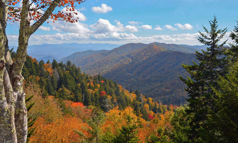
Autumn view from Newfound Gap one of the highest peaks in the Great Smoky Mountains of North Carolina
Fall colors appear first at the Smokies’ highest elevations (like Clingmans Dome) and work their way down to the foothills and then lower elevations over a 5-6 week season. So you should be able to find beautiful color no matter when you visit in the fall. There are plenty of great activities in fall – harvest festivals, leaf-peeper train rides, a pumpkin patch and more. But, if you want to explore our mountain roads to see the changing leaves, here’s a quick guide to find the most colorful foliage when you are visiting Bryson City in autumn.

You might want to check your gas gauge before heading out. These scenic drives don’t have gas stations along the way and, on most of the roads, the speed limit is around 45 mph. But that’s okay — take time to look around and enjoy the ride.
Three roads to the highest elevations — Newfound Gap Road in the Great Smoky Mountains National Park, the Blue Ridge Parkway, and the Cherohala Skyway — take you from the valleys and foothills up to the earliest color at the peaks of the Smokies. You will experience the range of the fall season changes along the way.
Newfound Gap Road / Clingmans Dome Road
Great Smoky Mountains National Park (GSMNP)
Start at the Oconaluftee Visitor Center just north of Cherokee (US 441). Watch the elk in early morning or late afternoon, visit the farm buildings, and enjoy the history museum. Mingus Mill, just a short distance up the road, is an interesting structure and a nice photo opportunity in mid-to-late fall. NOTE: if you plan to stay more than 15 minutes at any of these stops you will need a parking pass; kiosks located at Visitor Center.
You will travel through a canopy of trees beside the Oconaluftee River before the views begin to open up as you drive higher into the Smokies. There are a couple of really good long range view spots with parking along the way to Newfound Gap parking (25 mins). Enjoy the views and check out the plaque commemorating the dedication of the GSMNP on September 2, 1940. A great photo opportunity is at the state line, where you can have one foot in NC and one in TN.
Just beyond the Gap, take the turn on Clingmans Dome Road, which takes you 7 miles across a ridge of the Smokies to parking for the observation tower. At 6,642 ft. elevation, this is where the earliest changes in leaf color occur, but the long-range views from the tower open up a variety of colors before you. The half-mile path to the 54-foot observation tower is paved with benches for resting along the way. There is a gift shop and restrooms.

Water flume powers Mingus Mill
Blue Ridge Parkway
Cherokee to Balsam Gap
A nice short segment of the Blue Ridge Parkway begins on US 441 in Cherokee at BRP milepost 469 (the end of the Parkway) and travels 26 miles to the Balsam Gap exit at milepost 443, just west of Waynesville, NC on US 74. (Return to Bryson City on US 74). You’ll experience a range of foliage changes as you travel from about a 2,000 ft. elevation to over 6,000 ft. and back down again.
Along the way, you’ll pass the Big Witch Overlook with a view of Cherokee Valley; and Waterrock Knob (milepost 451) at the highest elevation, where there is a visitor information center, comfort station and a spectacular view. Take the half-mile trail to the summit for an even better view. The nearly-360 degree vantage point is uniquely suited for viewing – and photographing – sunrises and sunsets.

Blue Ridge Parkway
Cherohala Skyway
Nantahala National Forest
About an hour west of Bryson City is the start of the Cherohala Skyway, which begins outside Robbinsville, NC and travels about 50 miles to Tellico Plains, TN. You can enjoy all or just part of the Skyway, reaching elevations of about 5,000 feet at the Santeetlah Overlook. There are numerous overlooks along the way. Take a side trip to walk among large stands of colorful poplar trees in the Joyce Kilmer Forest. There is a restroom and picnic tables, and a nice 2-mile loop trail.

Cherohala Skyway
Shorter trips at lower elevations include the Road to Nowhere and the Nantahala Gorge.
Road to Nowhere
Great Smoky Mountains National Park
For a quick drive through a canopy of leaves at a mid-to-lower elevation, drive just a few minutes outside Bryson City and follow the “Road to Nowhere” in the National Park. It’s a six-mile drive with an overlook of Fontana Lake that ends at the mouth of a tunnel, which is a beautiful photo opportunity in the fall. Walk through the quarter-mile tunnel (bring a flashlight) to hiking trails and great fishing.

Road to Nowhere ends at this tunnel
Nantahala River Gorge
Nantahala National Forest
Known for premier whitewater rafting, kayaking, trout fishing and ziplines, the Nantahala Gorge drive begins west from Bryson City on US 19/74. As you drive between the river and the sides of the gorge, you’ll be surrounded by close-in color at a lower elevation and watching the rafters splash through the water. Travel 8 miles to Wayah Road, turn left and drive along the Nantahala River cascades enjoying small waterfalls and rushing water. Return to Bryson City by the same path.
Visit our Scenic Mountain Drives page for more roads to travel in fall – or any time of the year.

October rafting on the Nantahala River
Bryson City - Swain County
Chamber of Commerce
P.O. Box 509
Bryson City, NC 28713
Karen Proctor
Executive Director
828-488-3681